Author Archives: atsioneva

Trail Notes – August 7 (Gorham, NH – Tactical Retreat)

I did not do much of anything today, and yet I am feeling drained of energy. I suspect/hope it is only dehydration – my digestive system has not been very happy yesterday or today, and the day before yesterday, I did not drink nearly enough. I am working on remedying the situation.

Today I moved from the Hiker barn to the White Mountain Hostel. Stairs again, but they kindly juggled the sleeping arrangements so I have a bed instead of a top bunk. THEY HAVE A TUB. I was in nirvana, soaking in a hot Epsom-salted bath until the water cooled. I have not had a good soak in a tub in almost four months. Bliss.

I have decided I will stay until Wednesday morning, and then return to the trail at the point I left it. I still have Mt. Madison to climb, and when I make the long descent down to Pinkham Notch, I will be officially finished with the Presidential Range. Oddly enough, the way the trail curves, I will be back at this hostel on Monday; it is right on the trail, 24 trail miles from where I rejoin the AT. Since I am triple zeroing now though, I will not zero again next week. 

Between now and then, I finish the Presidentials, and climb five-peaked Wildcat Mountain. Unoriginally, though, the peaks are simply named Wildcat A-E. The climb up Wildcat E is the second steepest on the trail, second only to Katadyn itself. But – and this is a very strong possibility, I have to admit – there is a gondola that goes from Pinkham Notch to the top of Wildcat D, bypassing 3 miles of trail that includes the dangerously steep portion. I will see how my knees are feeling and what the weather is like. 

It feels very good to simply rest. I really hope that I am just dehydrated and will feel better tomorrow; tomorrow I will visit the post office and pick up maildrops. 

I pause.

Categories: Uncategorized | 1 Comment

Trail Notes – August 6 (Presidential Range, Gorham, NH – Tactical Retreat)

I woke up in the clouds. Madison Spring Hut is at 4800 feet, and the weather changed overnight. Visibility was very low; Mt. Adams, so close by, was invisible in the fog. While we were eating breakfast (BACON!), we watched the mists swirling in the wind, sometimes hiding, sometimes revealing the tiny trees just outside the hut. I still was not very hungry. But I ate.

I was hurting. My arm hurt, my knees hurt, my hands were sore from gripping the poles so tightly, I was banged up and bruised up. My plans to finish the Presidentials, do the steep climbs up five-peaked Wildcat Mountain, and then take a double zero in Gorham to celebrate went sailing off into the mists. I needed that rest NOW. 

After getting advice from the hut crew, I opted to take the much easier and more direct blueblazed Valley Way Trail down to Rt. 2 near Gorham, rather then stick to the AT – the AT has a steep climb up the last Presidential, Mt. Madison, then a long, steepish descent to Rt. 16, at Pinkham Notch. I was just not up to it at that point.

So, the blueblazed trail, while steep at times, was much, much easier terrainwise than anything I had done the day before. Eventually it leveled out to a pleasant dirt path walk in the woods, alongside a river with waterfalls. And then to the Appalachia Trailhead a few miles out of Gorham. I caught a ride into town with two others who had been at Madison with me. 

My first choice of hostel was already full, so I stayed at Libby’s B&B and Hiker Barn, run by a very kind man named Paul. At first, I wasn’t sure – the sleeping room was up a pretty steep staircase, and I didn’t want to keep going up and down, I wanted to rest the knees. But he set up a comfortable air matress for me downstairs and I slept well.

 I did take advantage of his daily shuttle to Wal-Mart to pick up some V8,  food for dinner, and most importantly, a knee brace. I would have bought two, but the place only had one of the kind I wanted. It is helping quite a bit. I also made reservations for Sunday and Monday at the White Mountain hostel I originally wanted to stay at, and I may extend that to Tuesday as well. I will see. 

I paused.

Categories: Uncategorized | 1 Comment

Trail Notes – August 5 (Presidential Range – Mts. Washington, Clay, Jefferson, and Adams)

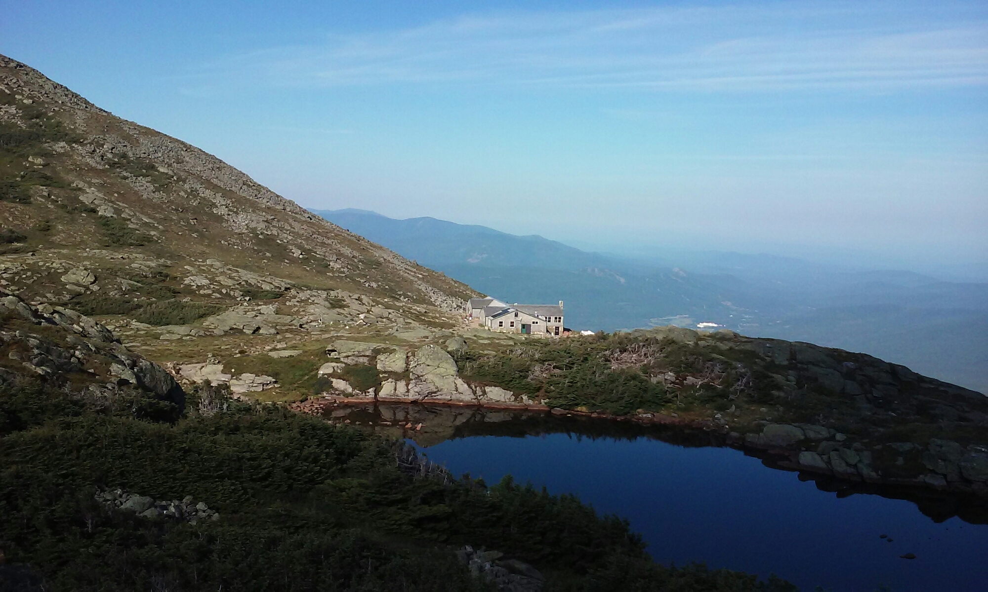
Photo taken looking back at the Lakes of the Clouds Hut from the slope of Mt. Washington.

I had a bunk! I woke up as early as usual, before the official wake up at 6:30 by the crew making lotsa noise. 🙂 Coffee was the first priority of the day. Breakfast was served at 7am. Oatmeal was first, with a good variety of toppings, including chocolate chips. Mmmm

And then came BACON! Coffee cake, more coffee, scrambled eggs, it was a good hearty breakfast and a great start to the day. baconbaconbaconbacon Because Mt. Washington was waiting… At every hut, at 7:15, the crew reads the official weather statement for the day, radioed down from the Mt. Washington Weather Observatory. At the LotC hut, if the weather up top is bad, they won’t let the guests hike up. But all systems go on this day.

I really enjoyed the climb to the summit, 1000 feet up. It was all rock, but large, fixed in place boulders, and I was going up, not down. It was a completely beautiful morning, sunny, low winds – I passed one of those signs warning that the area ahead has the worst weather in America and to turn back NOW if the weather is bad. That did not apply today! I made the summit by 10 am; I was not hurrying.

I dawdled up at the top while the phone charged. I bought, filled out, and mailed a post card; I bought and consumed a diet Coke and chicken tortilla soup; I wandered through the museum. I was not inclined to stand in the very long line waiting for pictures at the summit sign. You will just have to take my word for it that I was there. 🙂

I hung around until noon, with the phone at 75% charge instead of 6%. Good enough! Mountains waited. And finding the right path down the mountain was a bit confusing; but I managed to follow the right set of cairns to get on the Gulfside path. Which, incidentally crossed and then paralleled the cog railway for a while. No, I did not moon the passengers, but the thought was in my mind.

Coming around the side of Mt. Clay, an unpleasant reality sank in… Above treeline, when nature calls, there are very few places to take the call in private. Everything and everywhere is exposed to view. Eventually, the trail wound up into a rocky enough area, though, and just in the nick of time.

Rock, rock, rock. Boulders. Uneven footing, baking sun, no shade, little wind, for a while. I stopped to apply sunscreen, but could still feel myself drying up. Luckily, clouds came in and it cooled off before it got too bad. I kept on hiking, the trail wound around the side of Jefferson instead of up to the summit. But it was high enough up that the descent was steep, and of course, rocky.

And that’s where I took a misstep, and could not recover my balance with the poles, though I tried. I ended up lying head downslope on the rocks, the breath knocked out of me, and badly shaken. Assessing my injuries two days after the fact, I came off surprisingly well, for the type of tumble I took. A slightly twisted right knee, a sizeably bruised and sore right forearm, and a cut on the forehead. I groped for my poles, shakily hauled myself upward, and continued on, albeit much more slowly. 

It was at this point that the Madison Hut became my fixed destination, instead of the campgrounds I was aiming for. But between Jefferson and the hut, Mt. Adams waited. Fortunately, just at the point my spirits and energy were lowest, I caught up with a small group of three other hikers. Somehow, as the tail-end of this group, I drew energy from them, to get up the steep, rocky side of Mt. Adams pretty quickly; again, I did not have to summit it. But at the point of descent, there was still a mile to go, and both knees were complaining, the right more than the left.

I swallowed some Advil, and just kept following the cairns downward, very carefully. The rocks were sharp, and you could tell the ones people usually used, because they had more green moss spots than the other rocks. It was a major relief when the hut came into view, but it was still a half mile away.

I wobbled into Madison Hut about 7 pm, while guests were inside having dinner. My first request was for an ice pack, and my second for work for stay. Both were granted, to my great relief. 

However… Never underestimate human kindness. My Cincinnati group from Lakes of the Clouds was at Madison, and one of them was gone… So they offered me his place, which was already paid for. I will be sure to send a thank you! So in an instant, I went from volunteer helper to honored guest, and the crew quickly rustled up some soup, bread, salad and chicken for me. Truth to tell, I was still pretty shaken up and my stomach was jumpy. I was not all that hungry, but I was so grateful I would not have to sleep in the floor that night. I retired to my bunk pretty quick, took more advil, and slept fitfully. The wind started howling about 2 am.

I hiked on. Okay, limped.

Categories: Uncategorized | Leave a comment

Trail Notes – August 4 (Presidential Range – Mts. Pierce, Eisenhower, Franklin, and Monroe)

Sunset in the Presidential Range

Oi, what a mountainy day! Ups and down predominated, but the overall direction was up, of course. Mizpah Hut was at 3800, I would end at the Lakes of the Clouds Hut at 5000 feet, only 4.7 miles further on. Yes, in time terms, a short day, but.

But the mountains stretched out before me like a line of tenpins. Immediately after leaving Mizpah came a 500 foot climb to the top of Pierce, and I was up above tree line again. I would stay that way for the rest of the day, with only brief flirtatious with stunted trees here and there. 

Side note: The odd thing about the AT in the Whites is that every section of trail has a name, and without a good map, sometimes it is impossible to tell which of the named trails is actually the AT. For example, this day I was on the Webster Cliff Trail initially, but had to get onto the Crawford Path later. The AMC does have good signposts at the trail intersections, but it can still be confusing!

After Pierce came Eisenhower. The AT was kind enough to circle this mountain, rather than making one go over a very rocky summit and back down, though there was a trail to the top if I wanted. I didn’t want. The circumventional trail strayed a bit too close to the drop off for my comfort at points, but was pretty easy. 

Franklin, I had to summit. I don’t recall it being too hard. I was starting to get the hang of climbing above tree line. Mt. Monroe was another circumvention around the mountain, rather than over, and I was getting excited at this point, because as I came around the curve, there it was… A large AMC hut nestled in the shoulder below Mt.Monroe. The Lakes of the Clouds Hut. And, rising just behind, the unmistakable bulk of Mt. Washington, 1000 feet further up, and the second highest peak on the AT. Excitement gave wings to my feet, and I quickly arrived at the hut.

When I walked in, I just wanted some soup, and then to stay in the “Dungeon”, a shelter for thru-hikers in the basement that costs $10 a night, and serves as an emergency shelter in the winter. Well, I went to look, did not like the look of the place, and did not want to do work for stay that day, I was pretty tired.So what to do?

This is where serenpidity wandered by again, and gave me a big push. Usually these huts are booked months in advance. As I was chatting with the crew member manning the desk, she mentioned that there were still three open bunks. Expensive as it was, I could not pass up the chance to experience this, and pulled out the credit card. One bunk and one unforgettable interlude secured. It was 2:30 and my hike was over for the day.
Oh, oh the view! The dining room stared out directly over the northern Presidential Range, with Mts. Clay, Jefferson, Adams, and Madison (I think) lined up just ahead, with Mt. Washington dominating just to the right. The line of mountains ahead was blue and silhouetted, Mt. Washington was a solid green and white reality that could not help but assert itself. 

After I finished gawking at the view (okay, I never really finished), I found a good book about an attempt to climb Everest, and settled down contentedly to read the afternoon away, off my feet. 

At some point during the afternoon, one of the crew members was doing a question and answer session outside, and demonstrating with one of the typical packboards they use to carry trash up the mountain, and food down. The Lakes of the Clouds crew has it easier than the rest of the huts – Mt. Washington summit is only a mile and a half away, and there’s the auto road to the top. A lot easier for carrying loads! I tried on the packboard, and my respect for them grew even more – the empty wooden frame alone was 12 lbs! They typically carry between 60-80 lbs on their loads. In contrast, my pack is 25-30 lbs, depending on amount of food and water.

Dinner was at 6:30, so they shooed us all away from the tables at 6:00 so they could set them. And what a dinner it was! Having leftovers in the kitchen during a work for stay did not begin to prepare me for dinner. All dishes were served family style. First came incredibly tasty pumpkin soup, then an Alpine salad… Mmmm, fresh greens! Black bean enchiladas with sour cream, freshly baked bread, cheesecake brownies, coffee, cocoa, ice water. All you can eat. I was so full by the end! 

I also had a great group of tablemates – a group from Cincinnati who have been doing sections of the AT for years. This year they were hut hopping through the Whites – I’d been inadvertently pacing them, or vice versa, since Zeeland Hut. We hit it off well, and it was so refreshing to have a meal that involved real conversation, that one could linger over and just enjoy, where no camp chores were required. 

Lights out/quiet time was at 9, so I went off to my bunk. The room was full of Boy Scouts and troop leaders, but earplugs muted snoring, the view out the window was incomparable, and I drifted off into a contented sleep. It was a DAY among days.

I hiked on.

Categories: Uncategorized | Leave a comment

Trail Notes – August 3 (Crawford Notch, Presidential Range – Mts. Webster and Jackson)

I was the first one up and packed on this particular morning – in fact, the others in the shelter were just waking up as I slung the pack on at 6:30 or so. I was hoping to see the moose at the pond, but no such luck, as I went by. Today’s hike plan was short and simple – descend 1600 feet to Crawford Notch, climb almost 3000 feet to the summit of Mt. Jackson, end the day at Mizpah Hut.

Well, the descent was easy, following an old grade for a long gone railroad track. 3 miles down to Rt. 302 at the Notch. 

The Saco River runs parallel about a tenth of a mile north; since this was supposedly the only source of water for miles, I had no choice but to get water here, though for a river, it was very slow moving and I didn’t like the look of the water. I even tried using a thin shirt stretched over the top of the bottle to filter out any floaties, but it didn’t work too well, and I had to carry a wet shirt after. I sterilized the heck out of that water though.

Webster Cliffs, and Webster Mt. Billed as a tough climb. I didn’t find the cliffs technically difficult, but it was a very long climb. Some great views though. From the Cliffs to Webster mountain itself was a very steep 0.9 miles, with a fair amount of hand over hand rock scramble. Now, I have a very poor sense of distance, and I passed one false summit on the way, so when i arrived at the actual top of the mountain, I thought I was at the top of Mt. Jackson, not Webster. A British group also at the summit crushed my optimism – “No, this is Webster”. I forgave them. They had cool accents.

So, nothing for it but to push on over Jackson. Now, this was tough. A lot of hand over hand, and at one point, very carefully making my way up a sheer rock face of bare white stone at the side of the mountain. This wasn’t sloped, this was almost straight up, sweating bullets, knowing that if I messed up, severe injury or worse would follow. But I felt proud after for making it.

From the top of Jackson 1.6 miles to Mizpah, there was a lot of buttscooting and bogs. Fortunately not at the same time! The descent was steep, too, and sitting on one’s butt and sliding until one’s feet touch the ground is a tried and true technique. Not so good for the shorts though. After the descent, though, the trail was pretty easy.

Finally, finally reached Mizpah Hut. Yes, work for stay was available; the food was really good. This but has a separate game room/library which was excellent; since hikers slept there instead of in the dining room, we didn’t have to pack away gear before they set the tables downstairs, though we were all awake early anyway. Usually the huts only allot 2 WFS slots – at this one, there were five of us!

For their usual breakfast skit, encouraging guests to pack out trash, fold blankets, and tip the crew, they did a Harry Potter and the Sorcerers Stone take-off. I was hanging out in the gameroom when they borrowed the chessboard for the performance. 🙂 But I am getting ahead of myself, that was the next day.

I slept well that night. It had been a tiring 10 miler!

I hiked on.

Categories: Uncategorized | Leave a comment

Trail Notes – August 2 (Ethan Pond)

My mood had much improved by wake-up in the morning. While waiting for the hut guests to eat, I went down to the falls and lay on the granite, relaxing while the water rushed past a few feet away, then poured over the rocks in a series of falls. It was very similar to Sioux Falls, save for the type of rocks.

A short day. A pattern was beginning to emerge – short day, long day, short day. Some kind of hiker SOS? Maybe! This one was only 4 or 5 miles; I stopped early because I was rain-scared, and thought I saw dark clouds coming in. I did not want to get my other set of clothing wet. Even when not raining… the path would push through short pines at the altitude I was at. The effect was similar to the side brushes in a carwash. Constant cold wet brushes. Eeesh.

So, anyway, I stopped early, even though the path from Zeeland Falls was quite easy. I was of two minds about this, but I lay down to take a nap, slept longer than planned, and that settled it. Apparently a moose came and went at the pond while I was asleep. Very annoying.

Later, other hikers arrived and my mood improved. There were also two groups – one of trail maintainers, and a younger, mixed-sex group. The latter was fascinated by the leeches in the pond – myself and a Canadian section hiker were down there chatting and enjoying the pond views, particularly at sunset, but peace and quiet were not to be found for a while. Still, I did get some beautiful reflection shots before heading back up to the shelter. Very rocky terrain!

The shelter was almost full that night, and there were several tenters as well. This was an unusual shelter – the cooking area was pretty far away from the shelter, and covered with a tarp. Also, one of the groups was CHOPPING UP FRESH VEGETABLES RIGHT IN FRONT OF ME AND MY MOUTH WATERED UNCONTROLLABLY.

Ah, yes. Caps lock got stuck. Really. I was perfectly happy with boiling water poured into a pasta side. Really…

I hiked on.

Categories: Uncategorized | Leave a comment

Trail Notes – August 1 (South Twin and Guyot Mountains)

The word for this day was…miserable. The rain that had been threatening for days finally got serious. Oh, did it ever.

But between the rising and the rain lay the Galehead Hut. I stopped there for some baked goodies and a bowl of soup. Both exceptionally tasty! Fit to power me up the extremely steep South Twin Mountain. 1100 feet increase in 0.8 miles; quite dramatic on the map.

Or I thought it was enough to power me up. Not ten minutes after I left the Hut, down came the rain. And at 4902, the peak of the mountain is above treeline; there is nothing to stop the wind, and rain turned to little ice pellets. I had to get off the mountain before I froze. Fortunately, the trail steeply dropped off as well, back into the trees, but the rain continued for hours. Hours. My waterproof boots were squishing water, but once in, there was no getting it out. Somehow, though I had the rain cover on the pack, the sleeping bag got wet, too. Since it is synthetic, it was annoying, but not disastrous. A down-filled bag like my summer bag would have been dank and useless for warmth until it dried.

I pushed on, cursing the trail, and the rain, and myself. I started running through a list of all the most dramatic ways I could announce that I was quitting the trail, and oddly enough, that cheered me up and kept me going. Maybe I really am a drama queen.

Onward, and onward, and onward. A nine or ten mile day ended at Zeeland Falls Hut, where I would again do work for stay. It was dry! Part of the path was crossing between the multiple waterfalls; at that point I couldn’t bear to see any more water and just pushed on to the hut.

Sleeping at Zeeland, however, was to the sound of the falls, which was very soothing. Once again, just me and one other thru-hiker. I was very grateful the day was over. My boots would not fully dry for another two days… And the long wool socks eventually registered an 11 on the smell scale. I switched to the backup pair.

I hiked on.

Categories: Uncategorized | Leave a comment

Trail Notes – July 31 (Franconia and Garfield Ridges)

Aaaaaand… We are back online!

When we last saw the Ziptie, she was hanging out on a porch at Greenleaf Hut. Dinner leftovers that night were delicious, but I cannot remember what they were. The assigned chore was washing dishes at night and sweeping in the morning. It is amazing how great it felt to do mundane chores! After they turned the lights out at 9:30 pm for quiet time until 6:30 am, me and the other thru-hiker slid the benches in under the tables, and set up our sleeping gear in the dining room. I slept well!

The next morning, we had to have our gear packed up before the crew started setting the tables at 6 am. No problem. The other thru-hiker left early, but I stuck around for leftover pancakes and coffee at 8 am, in the kitchen after all the guests had eaten. Then the sweeping, and then the long, hard climb back up to Mt. Lafayette. It was much easier, going up, and fresh in the morning.

But I still stretched out on the granite for a while at the top.

Mt. Lafayette had several smaller peaks to climb and descend before the Garfield Ridge veered off at a near right angle. It was a consider able psychological relief to get back below tree line. I grew up in the Green Mountains, not the Whites.

Counting the Greenleaf excursion… It was still a short day. But not a cakewalk. Roughly 6 miles; I ended up staying at Garfield Ridge shelter, which is run by the Appalachian Mountain Club, has a caretaker, and costs $10. The caretaker is a musician, brought out her guitar and sang her original hit song about what it meant to caretake at a shelter. All in all, a fun night, with good social interaction! I sheltered up; the recurring problem with all the campsites in the Whites is that they have tent platforms, which do not accommodate non-freestanding tents such as mine easily.

I hiked on.

Categories: Uncategorized | Leave a comment

An Apology

Yes, I still live! But cell reception has been very chancy and unreliable, and now that I have it, I am down to 21% battery in a high altitude hut with no electrical outlets. I will update with the missing days when the happy facts of reception AND battery life coincide.

In the meantime, my knees hurt. I am 1.5 miles from Mt. Washington, which I will climb tomorrow.

I hike on!

Categories: Uncategorized | 1 Comment

Trail Notes – July 30 (Franconia Ridge)

Oh, people.

Curiosity nearly killed the Ziptie.

The day started with pancakes and a shuttle to the Liberty Springs trailhead at Franconia Notch. And it was up, up, up, to the Franconia Ridge. 3 miles of rocky path – boulders and bedrock. Not difficult, just incredibly tedious, picking through the river of rock. 3 miles put me at the Liberty Springs shelter, where I made sure all three water containers were full; there is no water on the 5 or 6 mile ridge.

After the shelter, the trail was level for about a mile, then developed a mild case of Kinsman envy, and decided to throw in some vertical rock scrambles on the way up Little Haystack Mountain. At 4800 feet, I was above tree line and stayed above tree line for 2 miles. I put a rock,on the cairn at the summit of Little Haystack and continued on.

I was walking the ridge. I was walking the ridge above treeline. The weird thing about the path above treeline was that… you could clearly see it, a mile further on, wending it’s way from mountain to mountain. You could see the people hiking, very clearly. I tried to get a good picture, but my screen was washed out, and I must have missed the button. I will try again tomorrow.

Even though the trail was in the middle of the ridge, and avoided sheer dropoffs, I was edgy. From Little Haystack, it was on to Mt. Lincoln, which had three peaks. There was some rock scrambling, but mostly a straightforward dirt/rock path that only briefly dipped into tiny pine trees. I put a rock on the cairn at the summit, and continued on.

Then, Mt. Lafayette. Here I took a real break; stretched out on some comfortable granite, pulled my baseball cap over my head and enjoyed the sun’s warmth and breeze’s coolness. I put a rock on the cairn at the summit, and continued on…

… And here is where curiosity struck. The Appalachian Mountain Club has a series of huts in the White Mountains – essentially huge bunkhouses that also serve dinner and breakfast. They cost an arm and a leg to stay in. Thru-hikers, if they are lucky (usually a max of 2) can do work for stay – dinner and breakfast leftovers, plus space to sleep in the hut, in exchange for two hours worth of chores.

So, like I said, I was curious, and decided to try my luck at Greenleaf Hut, which is actually the furthest from the AT – 1.1 miles down a side trail from the summit of Lafayette. What I knew and just pushed aside was that it was 1.1 miles of steep rocky trail down. Can say that my body is NOT happy with me. Particularly the knees, going downhill kills the knees.

But I made it, and am now sitting on the porch typing while the paid guests have their supper. I get to eat after, and find out what my chore will be. Tomorrow, I climb back up that trail. Up is easier.

I’ve figured out I need a new strategy for the Whites – I will not plan where to stay each night, because I never know how far I can go, depending on terrain. So when I feel like I can’t go anymore, I will find the nearest shelter, or stealth camp, or try work for stay. At least in New Hampshire.

I’m starving. Granola bar time.

I hike on.

Categories: Uncategorized | Leave a comment

Blog at WordPress.com.